Touring Routes
Explore the Miami Valley and beyond.
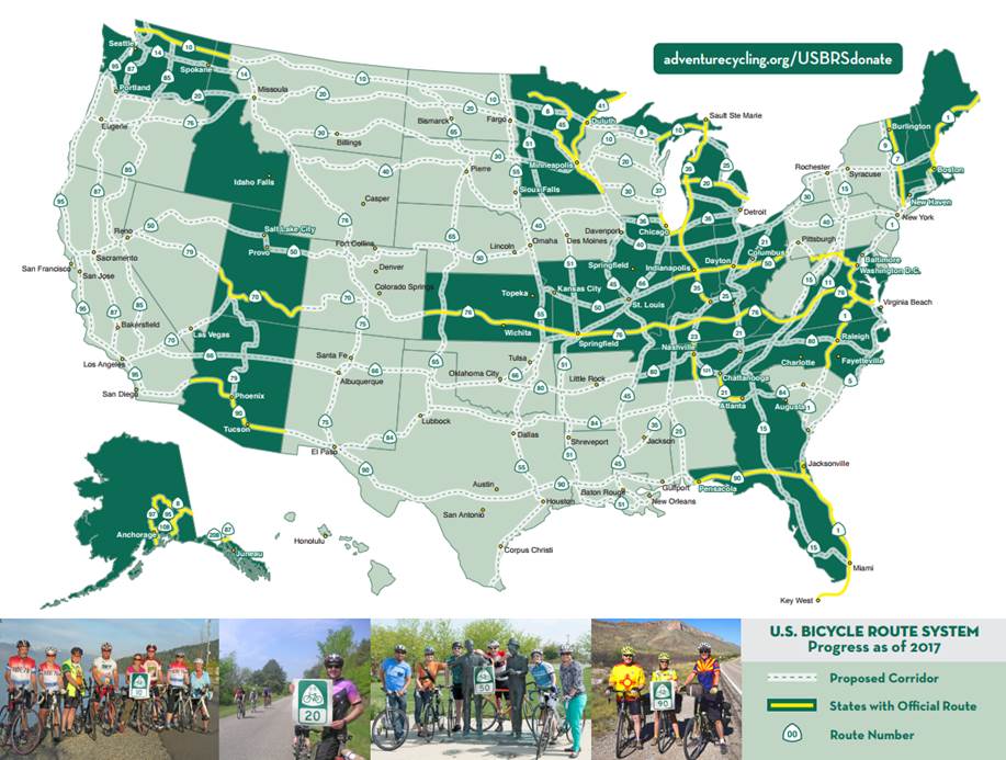
The 340 miles of the Miami Valley Trails are part of a larger network of the U.S. Bicycle Route System (USBRS) and the Adventure Cycling Route Network.
These routes are gaining in popularity along with the growth of bicycle tourism so you may encounter bicycle adventurers from around the world who are traveling these routes through the Miami Valley.
You also don’t need to stop when you get to the end of the Nation’s Largest Paved Trail Network, follow a USBR or Adventure Cycling Route and join the adventure!
Adventure Cycling Route Network
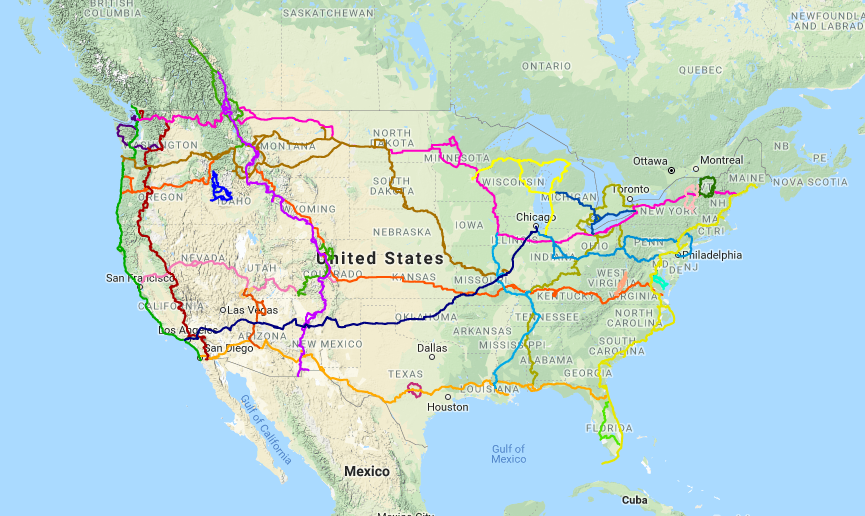
The Adventure Cycling Route Network features rural and low-traffic bicycling routes through some of the most scenic and historically significant terrain in North America. Since Adventure Cycling Association mapped their first route in 1976, the TransAmerica Bicycle Route, the Adventure Cycling Route Network has blossomed into an awe-inspiring network of 46,846 miles.
Adventure Cycling Routes are made up of a main route and include spurs and alternate routes allowing you to customize your experience.
Cyclists touring the area have the opportunity to experience the Greater Dayton Region via the Chicago to New York City Bicycle Route (CNYC) and Underground Railroad Bicycle Route (UGRR) via Great Miami Riverway Alternate (GMRA).
The route network is popular with traveling cyclists because the routes are fully mapped with the needs of a cyclists in mind and the routes are typically not the shortest distance between A and B. The route will often wander a bit on more rural or less trafficked roads.
Adventure Cycling maps include turn-by-turn directions, detailed navigational instructions for the tricky sections, and elevation profiles. The maps provide information specifically for cyclists: the location of bike shops, sources for food and water, and listings of overnight accommodations including camping facilities, small hotels, and cyclists-only lodging.
Chicago to New York City Bicycle Route (CNYC)
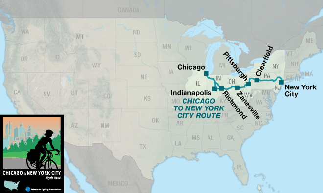
Unveiled in 2017, the newest Adventure Cycling Association Route takes people from Chicago to New York City right through the heart of Dayton and the Miami Valley utilizing the Wolf Creek Trail, Great Miami River Trail, Mad River Trail, and Creekside Trail. Cyclists could also choose to take advantage of the Great Miami Riverway Alternate to explore more of the Miami Valley.
The Chicago to New York City Bicycle Route (1160.3 miles) includes a main route and the Philadelphia Alternate (1172.9) which includes the Great Allegheny Passage (GAP).
The CNYC can be combined with Bicycle Route 66 for riders who wish to continue to or start on the west coast.
Underground Railroad Bicycle Route (UGRR)
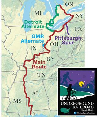
The Underground Railroad Bicycle Route (UGRR) memorializes the Underground Railroad, a network of clandestine routes by which African freedom seekers attempted to escape slavery before and during the Civil War. The 2,006.5-mile Underground Railroad Bicycle Route runs from Mobile, Alabama to Owen Sound, Ontario.
Locally, the route follows the Little Miami Scenic Trail and Ohio to Erie Trail. You have the option to connect into the history and amenities along the Great Miami Riverway including Dayton and many Five Rivers MetroParks by using the 51.4 mile Great Miami Riverway Alternate (GMRA).
In addition to the Great Miami Riverway Alternate (GMRA) you may also be interested in the UGRR Detroit Alternate, UGRR Pittsburgh Spur, or the day-trip rides in Ripley, Ohio (PDF).
Great Miami Riverway Alternate (GMRA)
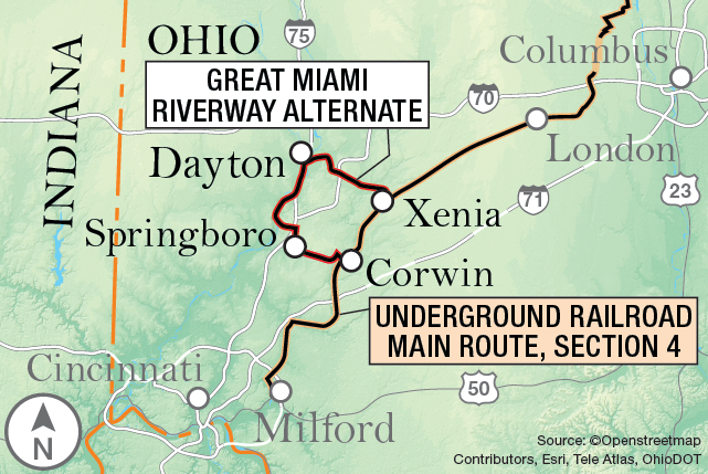
The 51.4 mile Great Miami Riverway Alternate (GMRA) provides travelers with the opportunity to experience the rich history of Warren, Montgomery, and Greene Counties by traveling through quaint communities and along the urban riverfront of Dayton, an Outside Magazine Best Town. Much of this alternate route connects the river towns and amenities of the Great Miami Riverway.
You’ll discover hidden nuggets of fascinating facts around every bend. You’ll travel from Corwin and Waynesville through Springboro on road before transitioning to off-street paved trails for the remainder of the route through Miamisburg, Dayton, and on to Xenia. Miamisburg is also proud to be the Sister City to Owen Sound, Ontario; the northern terminus of the Underground Railroad Bicycle Route (UGRR).

Local Touring Loop Option
While long distance cyclists on the main route of the UGRR have a 51 mile alternate route to experience the rich history along the GMRA; local cyclists can experience a weekend tour by choosing to loop back to their starting point using the Little Miami Scenic Trail to create a 65 mile tour with B&B and trailside camping opportunities at several places along the route.
Project support provided by:
U.S. Bicycle Route System
The U.S. Bicycle Route System (USBRS) is a proposed national network of bicycle routes, which will link urban, suburban, and rural areas using a variety of appropriate cycling facilities. In some states, Adventure Cycling routes will be incorporated into U.S. Bicycle Routes, along with other regional and state routes.
To get maps of designated U.S. Bicycle Routes, visit Adventure Cycling’s “Use a U.S. Bicycle Route page”. The USBRS system is an ongoing project with individual routes designated at the state level (dark green state/yellow route on map below). 12,000 miles in 25 states have been designated.
U.S. Bicycle Route 50 (USBR 50)
USBR 50 was officially designated in Ohio in 2014 with signage installed across the state in 2017. This designated route is one more link in an east to west national bicycle route. In Ohio the route travels 313 miles from near Richmond, Indiana to Steubenville, Ohio utilizing both shared use paved trail and on road infrastructure.
 USBR 50 will eventually run from San Francisco to Washington, D.C. and generally follows Adventure Cycling’s Chicago to New York City Bicycle Route (CNYC).
The route travels through the Miami Valley primarily on the Miami Valley Trails including the Great Miami River Trail, Mad River Trail, and Creekside Trail.
See route across Ohio here.
Trailside Camping
MetroParks offers camping opportunities to cyclists traveling along the Touring Routes in the Dayton Region.
Trailside camping is available at Eastwood, Island and Taylorsville MetroParks. A trailside camping permit is required for all overnight use of the campsites. Permits for all overnight use can be obtained online or by calling 937-275-PARK (7275).
- Each location is large enough for two small tents.
- These are primitive campsites that can support up to four to six persons per site depending on the style of the tent.
- Each location is within 1000 feet of a restroom.
- Maximum stay per camp (Eastwood A, Island A, and Taylorsville A) is two nights.
Additional primitive campsites are also located a little further from the Touring Routes at Possum Creek, Englewood, Germantown and Twin Creek MetroParks.
