The area that is now Taylorsville MetroPark was once one of the busiest crossroads in the country, the meeting place of major transportation arteries — the Old National Road, Great Miami River, the Miami-Erie Canal and railroads. Today, the area serves as the crossroads of bike trails, hiking trails and river recreation. The park is a gateway to new outdoor experiences, such as running, biking, hiking, fishing and paddling. Your journey is waiting to begin.
If you’ve attended a Five Rivers MetroParks event or frequented your favorite park, you may recognize Chris Pion, MetroParks’ new chief of operations! For nearly 28 years, Chris has been on the MetroParks team in many capacities, most recently as director of parks. Pion started his MetroParks journey in 1996 as a seasonal park technician […]
Below you’ll find a list of programs and events for all ages, from children to life-long learners, in addition to MetroParks must-dos, sustainability tips and information on what’s growing in the parks this month. Take a deeper dive into your areas of interest by signing up for MetroParks’ email newsletters and following Five Rivers MetroParks […]
Emma Rowena Caldwell Gatewood, known as “Grandma Gatewood,” is considered a thru-hiking pioneer, one of America’s most famous hikers and a great ambassador for the Appalachian Trail. She is credited for helping save the nation’s foremost trail. She also helped build the Buckeye Trail, Ohio’s 1,444-mile long-distance hiking trail that circumnavigates the state – and […]
The Buckeye and North Country Trails pass through Taylorsville MetroPark. This section of the Buckeye Trail is part of a 1,440-mile continuous loop that encircles Ohio. The North Country National Scenic Trail stretches across seven states and will be 4,600 miles long when completed. These trails link historical and scenic features, making them accessible and provide long-distance hiking.
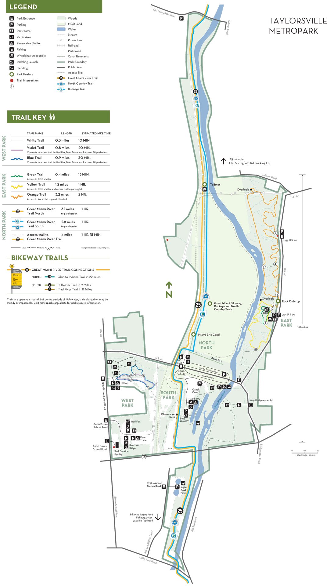
With more than 8 miles of trail and challenging elevation change, the trails at Taylorsville’s East Park offers hikers an opportunity to challenge themselves while immersed in an old-growth forest with stunning river overlooks. From the trailhead located just north of the stone shelter, you will find a variety of trail lengths and difficulty to make your experience fit your needs. Carefully choose a trail based on your hiking expectations, and be sure to come back often to explore and experience seasonal changes in this remarkable area.
The Great Miami River Trail bisects Taylorsville MetroPark from north to south. Travel to the north end and discover where the village of Tadmor once stood. Along the way look for the remnants of the Miami-Erie Canal. Go south from the dam and stand on an observation deck far above a native meadow. The park is a flat, 10-mile ride to or from RiverScape.
Village of Tadmor
The land where Taylorsville MetroPark now sits was once the site of the bustling town of Tadmor, one of the most important centers of transportation in early Ohio history.With all four means of transportation of the day within yards of each other, Tadmor was truly the crossroads of America.
Miami-Erie Canal
Running parallel to the Great Miami River through Taylorsville was the Miami-Erie Canal. This hand-dug “big ditch,” completed in 1845, took 20 years to construct. A great achievement in its day, it opened the state for commerce by connecting the Ohio River at Cincinnati to Lake Erie at Toledo with a navigable channel. Remnants of the canal can still be found on the north side of the dam near the paved Great Miami River Trail. Five hundred feet north of the dam stands the foundation of the aqueduct. These impressive structures were large, water-filled bridges over rivers that allowed canal boats to cross.
Rock Outcrop
A short walk from the CCC picnic shelter north of the dam leads to a huge pile of Brassfield dolomite with an exposed rock face behind. In 1984, this was the site of a massive rock fall when 375 tons of overhanging stone tumbled down. The collapse was caused by the erosion of the softer underlying Massey shale, leaving the stone above unsupported. This process repeated itself in 1996 when an additional 100 tons fell, and it continues today. Walk up the stone stairs and examine the small caverns created by water traveling through the stone over time. Enter the park at 2101 U.S. 40 and hike the orange trail.
Click to Explore
Accessible parking available. Accessible restrooms are located in the East, South and West parks as well as in the Reservable Area. The Blue Heron, Hilltop and Hackberry Shelters are ADA accessible.
An ADA water fountain is available at West Park next to the restroom and next to Hilltop Shelter. Water is also available at each shelter in the reservable area. A drinking water fountain equipped with a bottle filler is available at the Deer Trace shelter.
RTA Bus Route 17
Taking the Route 17 East Loop traveling northbound on Main Street through downtown will take you to Center and Brownschool roads. Walk down Brownschool Road about five blocks to the park entrance. Note: There are no sidewalks.
The park is accessible by foot or bicycle on the paved Great Miami River Trail.
Accessible restrooms are located in East, South, and West Parks as well as the Reservable Area (flushable). Portable restrooms are located in the North Park parking lot, Poplar Creek Ponds parking lot and in the Blue Heron Shelter Parking lot. A single pit toilet is available at the Shumard entrance.
A trailside campsite is nestled a short distance from the Great Miami River Trail under tree cover and tucked below grade of the trail at the opening to a tranquil grass field on the south side of Taylorsville MetroPark. It has one campsite with room for up to 2 small tents. Fires are NOT permitted in trailside campsites. A portable restroom is within 1000 feet and is shared with other park users. Potable water is not available in that area of the park, the closest is approximately one mile away in West Park on Brown School Road from April 1 to October 31. This site provides a great resting stop for backpackers of the Buckeye and North Country Trail along with bicycle tourists utilizing the Miami Valley Trails, the nation’s largest paved trail network.
The upper Great Miami River valley at Taylorsville includes a diverse area of floodplain and upland forest. Its rugged eastern portion includes an exposed limestone escarpment caused by an ever-flowing spring, and scenic wooded ravines sloping down to the river.
The conservation staff works to preserve the existing mature woodlands through the control of honeysuckle and other invasive species. Natural succession is permitted to occur in designated areas to maximize forest size, and young forests are helped along with the reintroduction and planting of native mast species.
The park also includes tall grass prairies, meadows and ponds that are managed to ensure biodiversity and support habitat for wildlife.
The highly diverse borrow areas east of the dam are also monitored and managed.
The park district protects a gorge and a little known 60-foot waterfall adjacent to the park, at the corner of National Road and Cassel Hills Golf Course. Sunderland Falls, named after the original 1805 landowners, feeds a stream to the Great Miami River and was an important stop for pioneers in covered wagons traveling the old National Road.
The strategic trail initiative was first started at Taylorsville, converting existing hiking trails in East Park into sustainable trails. Working with the land and sculpting trails using natural contours, sustainable trails reduce erosion and create large swaths of undisturbed habitat.
Fishing is available at the following locations. All require an Ohio fishing license, and state limits apply:
South Park Ponds
Poplar Creek Ponds: Bass must be released; rainbow trout can also be found in these ponds.
Great Miami River: The river is an excellent warm water species fishery with smallmouth and largemouth bass, panfish and catfish. A popular river spot is just below the dam.
The Great Miami River Trail makes its way through Taylorsville just to the west of the dam. It is paved and easy to maneuver for walking, running or biking. Running groups often meet here for runs because of the ample parking.Running, walking or skating north offers a trip along the historical Miami-Erie Canal and shaded woodland views, giving way to vistas of the Great Miami River.
Numerous species of animals and birds call Taylorsville MetroPark home. Coyotes have been seen in the park. See signs of beaver activity and look for warblers along the river and woodpeckers in the wooded areas. Birds to be found include both riparian and woodland species.
Beautiful examples of upland forest can be found at along the trails off of U.S. 40 along the Great Miami River. Upland forest is characterized by well-drained soil, flat or hilly terrain and trees that form a nearly complete canopy overhead. These forests contain a variety of tree species and might include sugar maple, oak, hickory, ash and beech. Beneath these tall trees is an understory that contains species such as dogwood, spicebush and pawpaw.On the forest floor, you will be able to find nonwoody plants and ephemerals (wildflowers) that bloom in the spring, capturing sunlight before the trees come into leaf.
There is a giant shumard oak, nicknamed Champion Oak, adjacent to the parking lot off of Bridgewater Road. This massive tree stands has a 240-inch circumference and a crown spread of 91.87 feet, scoring 357 points and making it the fourth largest tree measured in the MetroParks.
Try to find the endangered damselfly, the seepage dancer, at Taylorsville MetroPark. This little blue insect with a funny-sounding name is actually an indicator of the health of its wetland habitat. Park in the lot near the Blue Heron Shelter (off of the 2000 U.S. 40 entrance), or ride the Great Miami River Bikeway to the wetland south of the dam to spot this rare insect.
One of the largest mammals living in your MetroParks is the white-tailed deer. These Ohio natives can be found in almost any MetroPark — and sometimes even residential neighborhoods. Hike the orange trail at Taylorsville MetroPark and look for hoof marks near the river. Park in the lot near the 2101 U.S. 40 entrance, or access the park by riding the Great Miami River Bikeway.
Geocaching is an activity combining technology and nature, using global positioning system (GPS) devices to search for and find “caches” hidden throughout the world. Visit www.geocaching.com and search by location to get started.Then head out on an adventure to find the geocaches hidden in this park.
Hike the nearly 13 miles of scenic trails. Discover a rich variety of hiking terrain and numerous trail options. Loop trails in East and West Park are color-coded, with intersections marked by numbers that correspond to numbers on the inside map. Follow the same color to arrive back at your starting point. Trails are open year-round. The remaining trails throughout the park may not be loops. Please check maps.
The Buckeye and North Country Trails pass through Taylorsville MetroPark. This section of the Buckeye Trail is part of a 1,440-mile continuous loop that encircles Ohio. The North Country National Scenic Trail stretches across seven states and will be 4,600 miles long when completed. These trails link and make accessible historical and scenic features and provide long-distance hiking.
The land where Taylorsville MetroPark now sits was once the site of the bustling town of Tadmor, one of the most important centers of transportation in early Ohio history.With all four means of transportation of the day within yards of each other, Tadmor was truly the crossroads of America.
In 1839 National Road passed through Tadmor just to the north. For 50 years National Road was the busiest roadway in the country. With the construction of the Taylorsville Dam the road was rerouted to bring travelers across the top of the dam. Always a means for east/west travel, the road was heavily used through the Golden Age of automobiling in the1950s.
History and natural beauty come together in the Tadmor of Taylorsville MetroPark. Walking along the trail visitors discover ephemeral blooms in spring to blazing color in fall or hear the call of wild turkeys. Reflect on the past at Tadmor, once the busiest crossroads in the country. Imagine the physical toil of men hand digging the Miami-Erie canal, connecting the people and commerce of the Ohio River in Cincinnati with Lake Erie in Toledo, opening the state of Ohio to great development opportunity.
The Taylorsville Dam was built by the Conservancy District as a result of the 1913 flood. It was completed in 1922 and U.S. 40 was rerouted across it.
During the 1930s the Civilian Conservation Corps (CCC) built a number of structures in the East Park area to enhance visitor use. The CCC Shelter stands as a testament to the Corps’ work.
The land was leased to MetroParks 1966.The park opened to the public on April 1, 1967.
Discover unique low-lying floodplain meadows and forests as well as mature upland forests while taking in views of the Great Miami River. Taylorsville MetroPark east side trails take you through the heart of upland and floodplain forest. Wonderful year-round hiking provides views of the river, wildflowers and wildlife.
Taylorsville MetroPark contains exceptional examples of mature upland forest with many spring wildflowers, second-growth woodlands, natural succession areas, a few aging pine stands, a few managed grasslands and extensive floodplain forests along the Great Miami River Corridor.
The Great Miami River is popular with canoeists and kayakers. It is generally easy to navigate, but conditions vary. Trips often start upstream and use Taylorsville MetroPark as a destination. Watercraft are not permitted through the dam.
Take out upstream of dam from the 8-mile Tipp City section of the Great Miami River at the 2005 U.S. 40 entrance to the MetroPark.Put into the Great Miami downstream of the dam using the boat ramp at the 2000 U.S. 40 entrance to Taylorsville MetroPark for the 9-mile section of river to Island MetroPark. This section of river allows you to begin at a forested rivers edge and finish at the delights of downtown Dayton. Get the Great Miami River Water Trail Map and beware of portage around the low dams below Needmore Road and below Island MetroPark.
Unreserved shelters are available on a first-come, first-served basis. Picnic table sites also are available.
With sufficient snowfall, glide down the sledding hill at the Taylorsville West Park, 1200 South Brown School Road. Bumpy, grass turfwith a gentle grade, this obstacle-free hill offers safe long-distance sleddingdown a slope of 30 degrees with a 400- to 500-foot run.Sledding is not permitted on the dam.
Cross-country ski the picnic areas and open meadows. Most hiking trails are not suitable for skiing due to steep terrain.
Hiking trails are open all winter long in most MetroParks. Trails are packed snow.
Birding is a great way to learn about nature and get outside in your parks. From young to young at heart, people of all ages can enjoy this activity year round. Winter in Ohio offers many opportunities to explore the woods for songbirds.
Park Amenities & Activities
Latitude: 39.877099
Longitude: -84.169101
Spectacular wooded ravines, massive rock outcroppings, historical ruins and the Great Miami River make this large 1,400-acre park unique.