Hiking Trails
Dayton is a great hiking destination complete with quality trail, maps and resources along with nearby amenities such as camping, services, and supplies to support the hiker or backpacker.
North Country Trail and Buckeye Trail
Overview
Dayton region is home to a portion of the North Country Trail—a 4,600-mile National Scenic Trail, the longest in the United States—and the 1,444-mile Buckeye Trail, the nation’s longest circular trail. The BT/NCT share the same path for more than 800 miles, including the miles that run through Taylorsville, Island, Deeds Point, Eastwood and Huffman MetroParks.
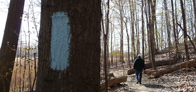
These long distance trails are co-aligned through the Dayton area as they are through much of Ohio, locally following the Mad River and Great Miami River paved trails. The trails are marked by 2×6 inch blue blazes along the route.
![]() In 2013, Dayton was designated a Trail Town. This designation showcases Dayton as a hiking destination complete with quality trail, maps and resources along with nearby amenities such as camping, services, and supplies to support the hiker along Ohio’s Great Corridor.
In 2013, Dayton was designated a Trail Town. This designation showcases Dayton as a hiking destination complete with quality trail, maps and resources along with nearby amenities such as camping, services, and supplies to support the hiker along Ohio’s Great Corridor.
Buckeye Trail
The Buckeye Trail (BT), Ohio’s State Trail, winds over 1400 miles through 48 counties around Ohio, reaching into every corner of the state. From a beachhead on Lake Erie near Cleveland, to a hilltop overlooking the Ohio River in Cincinnati, a hiker can experience a little of all that Ohio has to offer. Local volunteers work closely with the land managers to promote the trail and maintain the trail’s blazes. The Miami Rivers Chapter of the Buckeye Trail Association supports much of the work in the Dayton area.
North Country Trail
The North Country National Scenic Trail (NCT) stretches over 4,600 miles from New York to North Dakota linking communities, forests, and prairies across seven northern states and is administered by the National Park Service and supported by the North Country Trail Association.
Path
For an overview of the Buckeye and North Country Trail through the Miami Valley look for the blue dotted line on the Miami Valley Bikeways Map.
View Buckeye Trail info and maps
View North Country Trail info and maps
View a listing of camping and other services for hikers
| Mileage BT Total — 1400 NCT Total –4600 Region — 52 |
Surface Natural, Asphalt Region Section Start Dayton Drive at Central Ave, Fairborn Region Section End Lockington |
Contact Info troy@buckeyetrail.org 937-296-0245 |
Camping
Trailside camping opportunities are available to backpackers at three locations along the North Country Trail and Buckeye Trail as it passes through Five Rivers MetroParks. A trailside camping permit is required for all overnight use of the campsites. Permits for all overnight use can be obtained online or by calling 937-275-PARK (7275).
- Each location is large enough for two small backpacking tents.
- These are primitive campsites that can support up to four to six hikers per site depending on the style of the tent.
- Each location is within 1000 feet of a restroom.
- Maximum stay per camp (Eastwood A, Island A, and Taylorsville A) is two nights.
Twin Valley Backpacking Trail
Overview
This 27-mile backpacking trail, the Twin Valley Trail, is 30 minutes from downtown Dayton and has been featured in Backpacker Magazine. Set in the rolling hills of the Twin Valley, the TVT provides a backpacking experience reminiscent of other wilderness trails with beautiful hills, babbling brooks, abundant wildlife, history and small town charm.
The TVT combines the existing network of trails in Germantown and Twin Creek MetroParks with a connection to create a longer, more integrated trail system totaling over 45 miles throughout 2600 acres.
Directions & Parking
The Twin Valley Trail (TVT) is located in Southwestern Ohio, less than 30 minutes from downtown Dayton. The trail system can be accessed from trail heads at multiple park locations within Germantown and Twin Creek MetroParks.
Overnight parking for backpackers is available at:
- Germantown Main Park Trailhead spillway parking lot, 7101 Conservancy Rd.
- Germantown Trailhead & Sledding Hill, 6206 Boomershine Rd.
- Germantown Twin Valley Welcome Center Parking Lot, 6910 Boomershine Rd.
- Twin Creek Hopewell Trailhead, 8502 Chamberlain Rd.
- Twin Creek High View Trailhead, 9688 Eby Rd.
Multiple trail heads allow the hiker to tailor his or her experience from day hikes of as little as 2 miles to 29 miles. By adding the other trail loops in both parks, the available trail system is over 45 miles.
Maps
The Twin Valley Trail combines the existing network of trails in Germantown and Twin Creek MetroParks with a connection to create a longer, more integrated trail system. The three main components of the trail include:
- 7.5 miles along the Orange, Pink and Yellow trails at Germantown MetroPark
- 8.4 miles along the Orange, Purple and Silver trails at Twin Creek MetroPark, and
- A 5.4 mile connector trail that runs along Twin Creek and connects the two trail systems.
Total unique trail mileage is ~21 miles (to complete the trail and return to your starting point you would retrace the 5.4 mile connector for a 27 mile hike).
Download the Twin Valley Trail Guide
View the trail in our navigable mobile app
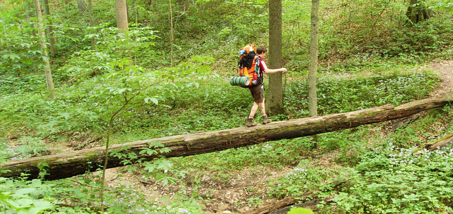
The Twin Valley Trail is marked by a backpacker icon located on posts placed along the trail. At some points the backpacker icon is painted on pavement to mark the trail. Other trails within Germantown and Twin Creek MetroParks are marked in various colors which are all loops and do overlap each other where applicable. These other trails offer you options to customize your route if desired.
Camping
Secluded camping opportunities are available to backpackers at three locations along the TVT. A backpacking camping permit is required for all overnight use of the backcountry sites. Permits for all overnight backcountry use can be obtained online or by calling 937-275-PARK (7275).
- Each location has three sites with each individual site large enough for two small backpacking tents.
- These are primitive campsites that can support up to four to six hikers per site depending on the style of the tent.
- Each location also has an outhouse along with a common area for cooking and hanging out that support the three individual campsites.
- Maximum stay per camp (Oak Ridge, Cedar Ridge, Pine Ridge) is four nights.
Other Camping Options
- Frontcountry camping is also available with a permit. They must be requested at least four days in advance.
- It is possible to combine backpacking and frontcountry camping options to create your itinerary. Be aware that if your trip includes frontcountry options you will need to reserve at least four days in advance whereas if you only use backcountry sites you can get a permit the same day assuming availability.
Water Availability
- Seasonal Potable Water: Available at Hopewell Trailhead in Twin Creek MetroPark, 8502 Chamberlin Road.
- Seasonal Stream: Germantown Old Mill frontcountry campsite, Twin Creek frontcountry campsites Tecumseh, Geronimo and Little Turtle;
- Pond: Germantown Oak Ridge backcountry campsite
- Dry: Germantown Shimp’s Hollow frontcountry campsite, Cedar Ridge backcountry campsite, & Twin Creek Pine Ridge backcountry campsite
- All water taken from ponds or stream must be treated
Fire Policy
- Fires are permitted only in frontcountry campsites (Old Mill, Shimp’s Hollow, Twin Creek Tecumseh, Geronimo and Little Turtle).
- Fires are not permitted in the backcountry camps (Oak Ridge, Cedar Ridge, Pine Ridge).
Recommended Hikes
Single-night trip
- Day 1: Park at the Germantown Trailhead & Sledding Hill and head north on the TVT, following the eastern half of the loop around Germantown 5 miles to Cedar Ridge Campsites.
- Day 2: Loop 6 miles back around to your car, following the western half of the loop around Germantown.
Two-night trip
- Day 1: Park at the Germantown Main Park spillway parking lot and follow the TVT 5.4 miles around Germantown MetroPark and camp under the stars at Oak Ridge campsites.
- Day 2: Hike 4.3 miles to Cedar Ridge campsites.
- Day 3: Enjoy a short 2 mile hike back to your car.
Three-night trip
- Day 1: From Twin Creek’s High View Trailhead, hike 3.9 miles to Pine Ridge campsites looping around the southern portion of Twin Creek.
- Day 2: Hike 10.3 miles following the TVT connector to Oak Ridge campsites.
- Day 3: Hike north from Oak Ridge and loop 6.9 miles around Germantown back to Cedar Ridge campsites.
- Day 4: Hike 4.2 miles back to your car.